Kataura Shin'yō Base Monument
Minamisatsuma City, Kagoshima Prefecture
In the last three months of WWII, the 124th Shin'yō Special Attack Squadron had 24
two-man Model 5 explosive shin'yō motorboats hidden in tunnels built into cliffs on
the side of the Kataura Harbor. These suicide boats were
ready to attack in case of an American invasion of southern Kyūshū, which never came. However, an accidental explosion soon after
announcement of the war's end caused the death of eight squadron members.
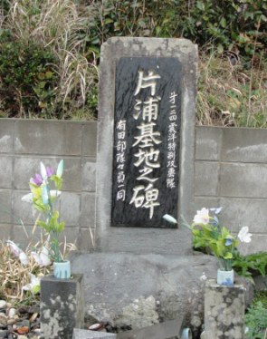
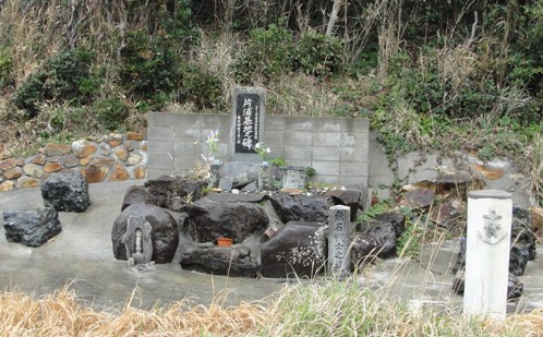
Former squadron members erected a monument in 1981 to remember the eight men
who died in the accidental explosion. The back of the monument lists the names of the
eight men at the top and has the following inscription:
In the latter period of the Pacific War, the Navy's 124th Shin'yō Special
Attack Squadron (Arita Unit) was stationed here in order to prevent Fukiage
Beach landing operations of the American task force. On August 19, 1945,
during the time of the
war's end, unfortunately an accidental explosion occurred
that took the lives of eight men.
At this time, through the cooperation of Kasasa Town authorities, squadron
members from those days and other interested persons gather together and
erect this monument with prayers for the spirits of those who died during
the war and for eternal peace for our country.
August 1981
After completion of training at Kawatana Torpedo Boat Training School in
Nagasaki Prefecture and formation of the 124th Shin'yō Squadron on March 24,
1945, the squadron members were on standby at Kawatana Naval Arsenal until May
5. They moved to Sasebo Naval Arsenal in Nagasaki Prefecture, where they were on
standby until June 3, when they departed Sasebo Harbor for Kasasa Town (since
2005 part of Minamisatsuma City) in
Kagoshima Prefecture. They finally arrived at the shin'yō motorboat base on June
13 after a delay along the way due to bad weather. Construction of the
shin'yō
motorboat base in Kasasa Town next to Kataura Harbor started in April
1945 by another shin'yō squadron, which moved to a different location when the
124th Shin'yō Squadron arrived.
The 124th Shin'yō Squadron had 6 officers, 49 motorboat pilots, 18 headquarters
personnel, 35 maintenance workers, and 124 base workers for a total of 232
members. The base had limited training facilities, so the squadron worked to
construct them, but sufficient training was not carried out at the base. The squadron members lived in triangular barracks erected on the
mountain slopes.
On August 15, 1945, even though a telegraph was received that the war had
ended, the squadron remained ready to launch the shin'yō explosive motorboats if
enemy ships were sighted. On August 19 at about 11 in the morning while men were
disconnecting fuses, an accidental explosion occurred that killed eight men and
injured several others. On August 26, the squadron's shin'yō boats were scuttled in
the sea. Two days later, the squadron commander started to release men to return
home.
The Kataura Shin'yō Base Monument is extremely difficult to reach on foot,
although someone with a small boat can easily get to the location.
Although hard for me to believe even now, I made six separate trips to the small
fishing village of Kasasa along the western coast of the Satsuma Peninsula in
Kagoshima Prefecture before I finally reached the monument.
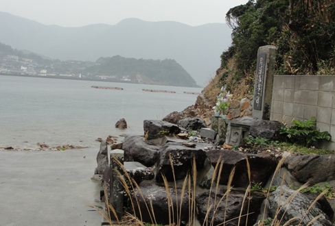
View of Kataura Fishing Harbor behind monument that honors
eight men of 124th Shin'yō Squadron who died during war
In October 2013, I made my first two trips to Kasasa. I got there by taking a
40-minute bus trip with only two or three other riders from Kaseda Bus Center to
Koura Bus Stop. I walked down a winding road to the water, since I thought that I would
be able to find the monument in a few minutes by looking around the harbor even
though I did not have the exact location. I walked around the water's edge for a
while without success and decided to go back up the hill to see whether someone
at the post office across from the bus stop could give me directions. The post
office worker said that she did not know and recommended that I go to the town
hall at the top of a hill. The young man who greeted me at the town hall
was extremely helpful when I told him where I would like to go. He made a copy
of a detailed contour map of Kasasa Town that showed all of the roads, and he
made a red line exactly where I needed to go to get to the monument. The
monument stood on the shore that faced Kataura Fishing Harbor along a narrow
mountainous peninsula about one mile long. He said to go down a paved path
almost halfway down the peninsula. Then he said I needed to use a rope to get
down a steep slope to the shore on the eastern side of the peninsula opposite to the
monument. After getting to the shore, I needed to walk about a quarter of a mile
and then cross over the peninsula in the place where he indicated with a red
line. Since it took about an hour to get to the monument on foot, he did not
think that I could make it that day since it was about 3 in the afternoon.
Regardless, I decided to go that day, since I did not want to make the trip back
on another day to this out-of-the-way fishing village.
I set out down the paved path and reached the end. The climb down the incline
to the beach, about 200 feet at a 40-45 degree slope, turned out to be not too
difficult with the assistance of the rope and trees along the dirt path. I
walked along the shore, which in places was more difficult than expected since
there were large rocks that needed to be traversed. I reached the spot to cross
the peninsula where the town hall employee had indicated on the map. Although
only about 150 feet across on flat ground, the underbrush was extremely thick with
tall weeds and other plants above my head. I was making slow progress
through it when I realized that I no longer had my eyeglasses. I had not
immediately recognized that they were gone, since the weeds were right in front of my face.
I could barely see due to my nearsightedness. I searched for
about ten minutes along the way I had taken and could not find them. I started
back to the bus stop since otherwise I would not be able to return before dark. Since I had time
the next day with a scheduled ferry departure from Kagoshima to Kikaijima in the
evening, I decided to return the next day to search for my glasses more
thoroughly. I looked for over one hour but had no success. I went to the western
side of the peninsula but could not see any monument, but I did not search much
due to my limited eyesight without my eyeglasses. On the way back a long snake on
the paved path surprised me, since I was almost upon it without my eyeglasses
before I recognized what it was.
In June 2014 during the rainy season, I returned to Kasasa to try again to
find the Kataura Shin'yō Base Monument. During the week before the visit, I heard
on TV that there was heavy rainfall in Kagoshima that was three times more than
a normal rainy season, but I did not pay too much attention, since I thought that it would not
impede my trip if a took an umbrella. When I reached Koura Bus Stop, it
was raining only lightly. I got down the slope with the rope successfully to the
shore, although I slipped a couple of times since it was muddy and slick on the
path down. After walking only about 200 or 300 feet, I stepped into some mud
with my right leg and started sinking. When the mud was over my knee, I panicked
but somehow got out, although I almost lost my shoe. Then I surveyed the shore
area more
closely and realized that there had been a landslide when I looked up
at the steep hill above the shore where the mud and rocks had come down. Since the mud
extended over the entire shore length of 30 feet or so and there appeared to be
no way to continue other than to swim around it in the water, I returned to the
bus stop without getting close to the monument. When I got to the slope and was
climbing up, the rope (actually several ropes tied together) broke and I slid
down in the mud several feet. It was impossible to get up the slippery muddy
path with no rope, so I struggled up a concrete water channel, rushing with
water from the prior rains, and finally made it to the paved path.
Two years later in June 2016 during the rainy season, I attempted to reach
the monument for the fourth and fifth times. I thought correctly that the
landslide on the beach would surely be cleaned up by now. When I reached Koura Bus
Stop in Kasasa in the morning, the weather was clear. After slipping to the
ground a couple of times in the mud on the steep slope to the shore, I took off
down the eastern shore toward the end of the peninsula. I successfully made it
to the western shore facing Kataura Fishing Harbor at the place indicated three
years before on the map prepared by the town hall employee. I thought that I
would easily locate the monument, but I could not find anything. I continued on
toward the end of the peninsula thinking that the monument must be just around
the corner, but the shore became extremely difficult to continue making progress
due to the large rocks and high mountain slope at the end of the peninsula. In a
couple of places the only way to continue was to wade through some shallow
water. Then it started to rain, but there was no cover in this area, so for ten
or fifteen minutes I tried to protect my shoulder bag from the driving rain by
just rolling up into a ball on the rocks. At one point I realized when I
turned back that I was much higher on the rocks in the beating rain, and I got
somewhat scared when I realized that I could slip and possibly hit my head on
the rocks if I fell eight or ten feet. So I retraced my path and returned to a lower elevation. Eventually I got to an overhang in the
cliff that provided partial shelter from the rain. About halfway back to the steep slope from
the shore to the paved path, I realized that I had lost my regular camera from
my bag probably sometime when I tried to protect my shoulder bag from the rain.
When I returned in the afternoon from Kasasa to my hotel at Kaseda (now also
part of Minamisatsuma City), I
searched Google Maps satellite view to try to find the monument. Surprisingly, I
quickly identified where the monument might be located, which was slightly south
of the location indicated to me by the town hall worker three years before.
Below is what I saw on Google Maps, and the green oval indicates the monument
location.
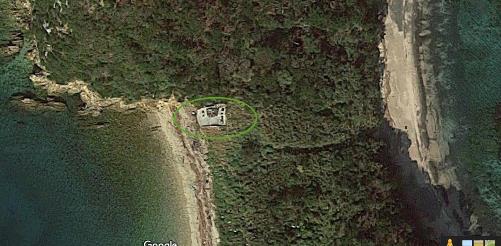
Location of Kataura Shin'yō Base Monument (inside green line)
I had before in my files an article published by students of Kasasa Junior
High School about the Kataura Shin'yō Base Monument, so I sent an e-mail to
the school to see whether someone could confirm the location shown
above on Google Maps. I also explained the path that I had taken that day based on the map provided
by the town hall worker. See blue line in satellite map below.
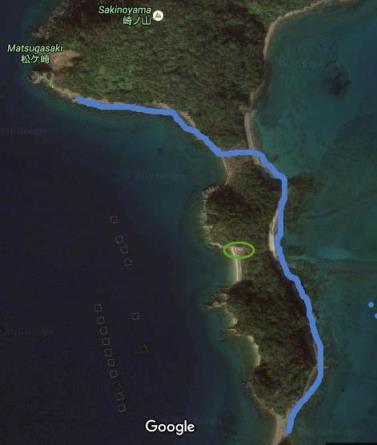
Shown in blue is the incorrect path that I took
to try to find Kataura Shin'yō Base Monument.
Green oval shows actual monument location.
Even though it was raining the next day, I decided that I would set out again
to Kasasa, since with my newly discovered information from Google Maps, although
not yet confirmed, I thought that I could reach the monument, although I
had some concern with mud when I made the crossing from the eastern to western
shore of the peninsula. As I was going down the steep slope from the paved path
to the shore, the rope broke, and I slid down a few feet. I decided then that a
hike to the monument was impossible in such heavy rain, so I struggled up the water
channel like two years before, since going up the slippery muddy path without a
rope could not be done. When I got to the paved path, I took off my pants and
washed them in a large puddle, since I thought that the driver would not let me
on the bus if I tried to ride it with so much mud on my pants that I had picked
up on my slide down the incline. When I got back to the hotel about noon, I
found a response from the Principal at Kasasa Junior High School who confirmed
that the green oval on the Google Maps excerpt was the monument location.
In March 2017, I finally succeeded in finding the monument. Although not the
rainy season, it was raining on the day I went, so I had much mud on me after
going down the steep incline by rope to the shore since I slipped a couple of
times. I crossed over from the
eastern to the western shore of the peninsula at the place indicated on Google
Maps, and I was surprised how easy the crossing went since the path I took had no thick underbrush or
mud. I could hardly believe it when I saw the monument, since I thought it must
be my fate to never get there. When I returned and was climbing up the incline,
the rope broke again like on a couple of prior trips, but by now I knew well how to get up to the paved path,
although it was still quite a struggle to go up the water channel. I tried again to wash my pants as well
as possible in a puddle on the paved path. By this time I was totally wet from the rain. On the
way back by bus to the hotel in downtown Kaseda City, I stopped by the
Bansei Tokkō Peace Museum. Since my clothes were all wet, I
felt cold later in the afternoon when standing at the bus stop to return to the
hotel. The next day I felt sick and weak, probably from wearing the wet clothes
for so long, but I felt happy that at long last I had found the Kataura Shin'yō Base Monument.
The historical information on this web page about the 124th Shin'yō Special
Attack Squadron is from pages 188-9 (written by Makio Arita, former 124th
Shin'yō
Squadron Leader) of the following book:
Shin'yō Association (Shin'yōkai), ed. 1990. Ningen heiki:
Shin'yō tokubetsu kōgekitai (Human weapon: Shin'yō Special Attack
Corps). Shirō Arai, general editor. Volume 2 of 2. Tōkyō: Kokushokankōkai.
|